
COLOR MY STATES · BLOG
The 5 Regions of the United States: States, Geography & Facts
Discover the Northeast, Southeast, Midwest, Southwest, and West, with complete state lists and a clear explanation of America’s different regional divisions.
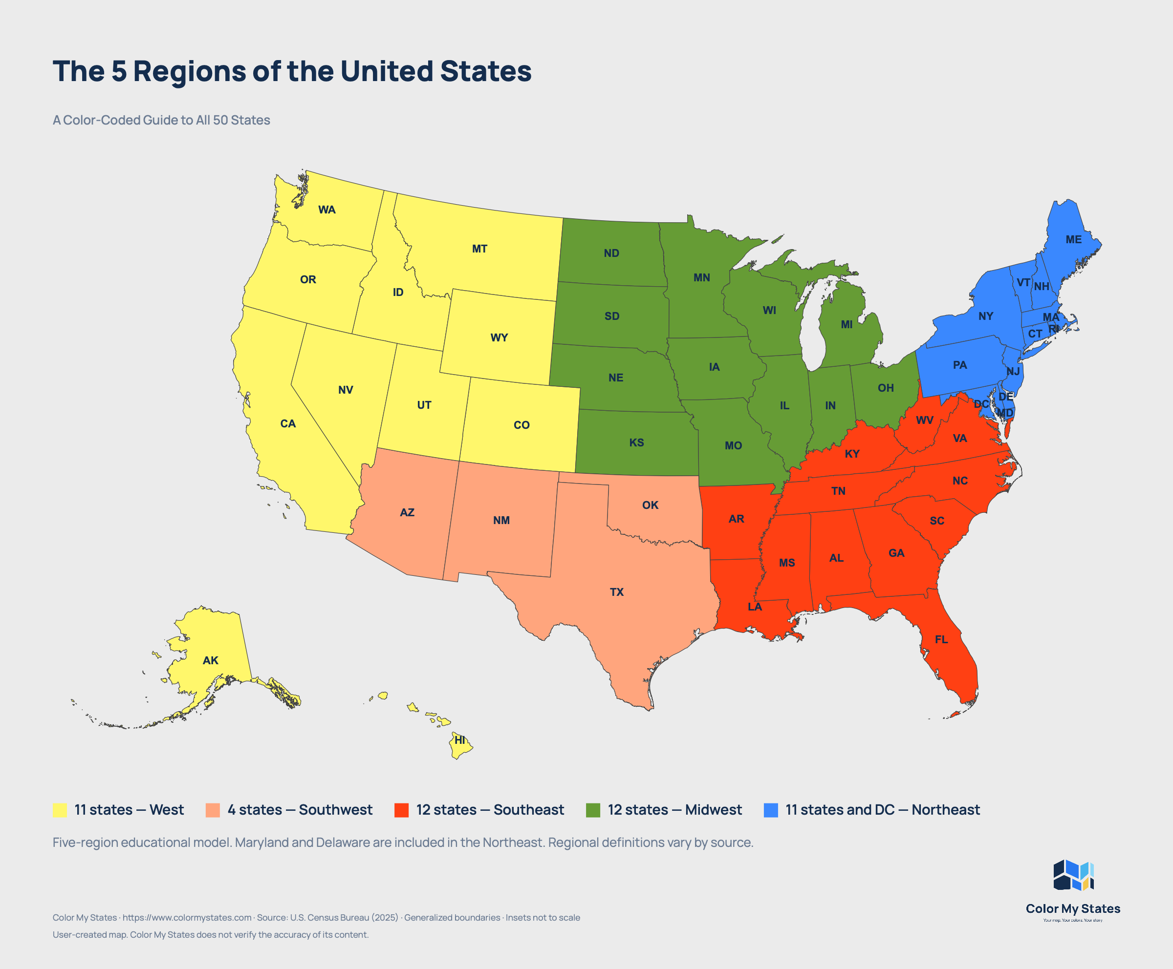
The five regions of the United States are the Northeast, Southeast, Midwest, Southwest, and West. Grouping the country this way makes it easier to understand where states are located and how America's landscapes, climates, and communities connect.
But there is a detail that can make US geography confusing: regional boundaries are not the same on every map. A classroom map, a travel guide, and a federal statistical report may organize the country differently.
This guide uses a five-region educational model that places Maryland and Delaware in the Northeast. Below, you will find all 50 states organized by region, an introduction to each region's geography, and an explanation of why other sources sometimes draw the boundaries differently.
What Are the 5 Regions of the United States?
The five-region model divides the 50 states into these groups:
| Region | Number of states |
|---|---|
| Northeast | 11 |
| Southeast | 12 |
| Midwest | 12 |
| Southwest | 4 |
| West | 11 |
| Total | 50 |
These counts apply to the classification used in this article. Washington, D.C., is a federal district rather than a state, and US territories are outside this 50-state overview.
1. The Northeast Region
The Northeast occupies the upper-right portion of a typical US map. In this guide, it extends from Maine south to Maryland and includes both New England and a broader Mid-Atlantic grouping.
Which States Are in the Northeast?
The 11 Northeast states in this guide are Connecticut, Delaware, Maine, Maryland, Massachusetts, New Hampshire, New Jersey, New York, Pennsylvania, Rhode Island, and Vermont.
New England is the six-state group of Connecticut, Maine, Massachusetts, New Hampshire, Rhode Island, and Vermont. New England and the Northeast are therefore related terms, but they do not mean the same thing.
Geography and Climate
The Northeast combines Atlantic beaches and rocky shorelines with wooded hills, mountain ranges, river valleys, and farmland. Maine's coast looks very different from the streets of Manhattan, while rural Pennsylvania and northern Vermont offer another side of the region.
Seasonal changes are pronounced across much of the Northeast. Winters are generally colder in northern and inland areas, while summers can be warm and humid. Coastal locations, southern areas, and higher elevations have different conditions, so the region should not be treated as having one uniform climate.
Cities, History, and Places to Explore
New York City, Boston, Philadelphia, and Baltimore are major urban centers in this grouping. Their ports, neighborhoods, museums, and historic sites offer different perspectives on American history, immigration, industry, and everyday life.
Outside the cities, the region includes New England villages, the Adirondacks, the Chesapeake Bay area, and the rocky coast of Acadia National Park. A regional map helps connect these places without suggesting that they all share the same character.
2. The Southeast Region
The Southeast stretches from Virginia and Kentucky toward Florida and Louisiana. It includes Atlantic coastal areas, inland mountains, major river landscapes, and warm southern lowlands.
Which States Are in the Southeast?
The 12 Southeast states in this guide are Alabama, Arkansas, Florida, Georgia, Kentucky, Louisiana, Mississippi, North Carolina, South Carolina, Tennessee, Virginia, and West Virginia.
Geography and Climate
The Southeast is much more varied than a map of beaches might suggest. The Appalachian Mountains extend through its inland areas, while coastal plains, wetlands, forests, and agricultural landscapes cover other parts of the region.
Much of the Southeast experiences hot, humid summers and winters that are generally milder than those farther north. Elevation makes a substantial difference: mountain communities can experience snow and freezing temperatures even when lowland destinations are much warmer.
Southern Florida adds another contrast, with tropical and subtropical environments that differ from the mountain landscapes of West Virginia or eastern Tennessee.
Cities, Culture, and Places to Explore
Atlanta, Miami, Nashville, New Orleans, and Charlotte illustrate the region's urban variety. Music, food, civil rights history, maritime traditions, and the histories and contemporary cultures of Indigenous communities all offer ways to understand the Southeast beyond its state boundaries.
Its natural landscapes are equally varied. Great Smoky Mountains National Park spans the North Carolina–Tennessee border, while Everglades National Park protects wetland, forest, and marine habitats in southern Florida. Both belong to the same broad region in this guide, but they represent very different environments.
3. The Midwest Region
The Midwest occupies much of the north-central United States. It connects the Great Lakes with broad stretches of the country's interior, including prairie landscapes, farmland, river valleys, and large metropolitan areas.
Which States Are in the Midwest?
The 12 Midwest states are Illinois, Indiana, Iowa, Kansas, Michigan, Minnesota, Missouri, Nebraska, North Dakota, Ohio, South Dakota, and Wisconsin.
Geography and Climate
The Great Lakes are a defining feature of the eastern and northern Midwest. Their shorelines support cities, shipping routes, beaches, and recreation. Farther west, the landscape includes extensive plains and agricultural areas.
However, the Midwest is not uniformly flat. The region also contains wooded hills, bluffs, dunes, and the Black Hills of South Dakota. Northern Michigan and Minnesota can feel very different from the open landscapes of Kansas and Nebraska.
Much of the Midwest experiences a substantial seasonal temperature range, with cold winters and warm or hot summers. Conditions vary with latitude and proximity to the Great Lakes, which influence nearby weather.
Cities, Industry, and Places to Explore
Chicago, Detroit, Minneapolis, Milwaukee, St. Louis, and Indianapolis are among the region's major cities. Agriculture, manufacturing, transportation, universities, and service industries all contribute to the Midwest's economy and identity.
For travelers and geography students, the region offers an opportunity to connect lakefront cities with agricultural landscapes, river towns, and prairie environments. The Great Lakes ecosystem also shows how natural regions can cross state and international boundaries.
4. The Southwest Region
In the five-region model used here, the Southwest consists of four states between the Southeast and the western mountain and Pacific states.
Which States Are in the Southwest?
The four Southwest states are Arizona, New Mexico, Oklahoma, and Texas.
Geography and Climate
Deserts, mesas, and canyons are closely associated with the Southwest, particularly in Arizona and New Mexico. Yet the region also includes mountains, grasslands, forests, and coastal environments.
Texas alone demonstrates why regional labels need context. Its western landscapes differ considerably from its eastern forests and coastal areas. Oklahoma adds extensive plains and other landscapes that do not fit the familiar image of a cactus-filled desert.
Climate varies accordingly. Lower desert areas can become extremely hot in summer, while high-elevation locations can have cold winters and snow. Eastern parts of this four-state grouping are generally more humid than its desert areas.
Cities, Culture, and Places to Explore
Phoenix, Albuquerque, Oklahoma City, Dallas, Houston, and San Antonio show the Southwest's range of urban settings. Native American nations, Hispanic and Latino communities, borderland histories, ranching, and continuing migration all contribute to the region's varied cultures.
Arizona's Grand Canyon National Park is a recognizable example of the region's canyon landscapes. It also illustrates why elevation matters: conditions along the canyon rim can differ considerably from those deeper inside the canyon.
Some travel guides use a broader definition of the American Southwest that includes Utah or parts of neighboring states. In this article's state-based model, Utah belongs to the West.
5. The West Region
The West combines Pacific states, inland mountain states, Alaska, and Hawaii. It covers a wide variety of environments, so it is especially important to avoid describing the entire region with one landscape or climate.
Which States Are in the West?
The 11 West states in this guide are Alaska, California, Colorado, Hawaii, Idaho, Montana, Nevada, Oregon, Utah, Washington, and Wyoming.
Geography and Climate
The region includes Pacific shorelines, the Rocky Mountains, the Sierra Nevada, dry interior basins, forests, and volcanic landscapes. Alaska adds Arctic and subarctic environments alongside milder coastal areas, while Hawaii contributes tropical island environments.
Even within the contiguous western states, conditions vary sharply. Coastal areas can differ from inland valleys, and mountain ranges separate wetter landscapes from much drier ones. Elevation influences temperatures, snowfall, and the length of the growing season.
A single description such as “warm and sunny” or “cold and mountainous” cannot represent the whole West.
Cities and Places to Explore
Los Angeles, San Francisco, Seattle, Portland, Denver, Las Vegas, Honolulu, and Anchorage illustrate how widely the region's cities are distributed.
Its parks also reveal contrasting landscapes. Yosemite National Park in California is associated with granite formations, valleys, and waterfalls. Zion National Park in Utah offers sandstone cliffs and narrow canyon scenery.
Remember that the West is broader than the West Coast. Colorado, Montana, and Wyoming are western states even though they have no Pacific coastline.
Why Do Some Maps Show 4 US Regions Instead of 5?
The number of regions depends on the classification being used. The U.S. Census Bureau groups states into four statistical regions: Northeast, Midwest, South, and West. Those regions contain nine smaller divisions.
The five-region educational model is a different framework. It should not be described as the Census system with one extra region added.
For example, the Census Bureau places Texas and Oklahoma in the South, but Arizona and New Mexico in the West. This guide groups those four states together as the Southwest. Maryland and Delaware also move: they belong to the Census South but appear in the Northeast here.
When comparing population figures or other regional statistics, check the source's boundaries before using its numbers. A statistic for the Census Northeast does not automatically describe the 11-state Northeast used in this article.
Are Maryland and Delaware in the Northeast or Southeast?
Both placements appear in five-region educational materials. This guide includes Maryland and Delaware in the Northeast, alongside the other states in its broader Mid-Atlantic grouping.
Other references make a different choice. The National Geographic five-region map places both states in the Southeast. Educational publisher History Gal provides versions with either placement, reflecting differences in classroom requirements.
For a school assignment, follow the map or instructions supplied by the teacher. For a custom map, state the classification clearly and apply it consistently. Moving these two states changes the Northeast and Southeast totals, so the map, legend, and accompanying text should agree.
How to Read or Create a US Regions Map
A color-coded US regions map makes the five groups easier to recognize. Start by checking the legend: colors are choices made by the map creator, not standardized geographic rules.
When creating your own map, use the state lists in this guide and give each region a distinct color. Keep state borders visible and include a written legend so readers can identify the groups without relying on color alone.
- Use one classification: check Maryland, Delaware, Texas, Oklahoma, Arizona, and New Mexico before you begin.
- Include all 50 states: Alaska and Hawaii belong to the West in this guide, even when shown in separate map insets.
- Check the totals: the five groups should add up to 50, with each state appearing once.
- Explain the boundaries: a short note can prevent confusion when readers compare your map with another source.
A suitable note for a map based on this article is: “Five-region educational model. Maryland and Delaware are included in the Northeast. Regional definitions vary by source.”
You can use Color My States to create your own colored US map. A regional map can support a geography lesson, illustrate a presentation, or provide a starting point for organizing places you want to explore.
Frequently Asked Questions About US Regions
What are the five regions of the United States?
They are the Northeast, Southeast, Midwest, Southwest, and West. This is a widely used educational framework, although the placement of individual states can vary between sources.
How many states are in each region?
In this guide, the Northeast has 11 states, the Southeast has 12, the Midwest has 12, the Southwest has 4, and the West has 11. Together, they contain all 50 states.
Is Texas in the South or the Southwest?
Texas is in the Southwest in the five-region model used here. It belongs to the South in the Census classification. The appropriate label depends on the purpose and boundaries of the map.
Are Alaska and Hawaii part of the West?
Yes. Both are included in the West in this guide and in the Census classification. Their placement in separate boxes on many US maps is a layout choice, not a separate regional category.
Is New England the same as the Northeast?
No. New England is a six-state part of the Northeast. The Northeast also includes states outside New England, such as New York, New Jersey, and Pennsylvania.
Are US regions official administrative units?
The five regions in this guide are geographic groupings, not governments or administrative units. Federal agencies also use their own regional systems for particular purposes, which can differ from educational maps.
Which regional map should I use?
Use the map that fits your purpose. Follow the assigned classification for schoolwork, Census boundaries for Census statistics, and a clearly explained grouping for a custom educational or travel map.