
COLOR MY STATES · BLOG
Which State Borders the Most States?
Missouri and Tennessee each have eight neighboring states. Explore our color-coded map and complete list to see how all 50 U.S. states compare, including the point contacts at Four Corners.
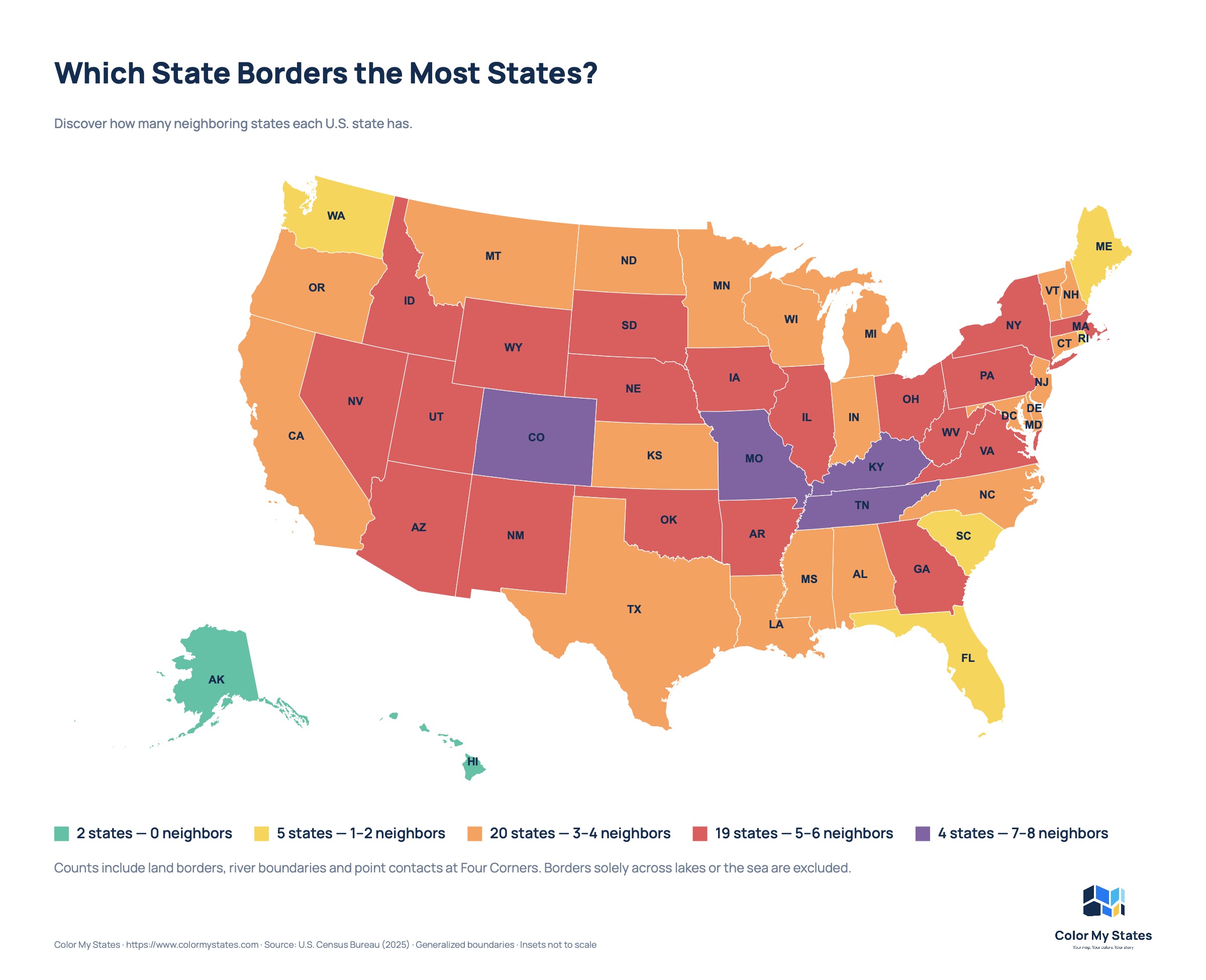
Some U.S. states have several neighbors. Others have just one, or none at all. Missouri and Tennessee border the most states: eight each.
This map shows the number of neighboring states for all 50 U.S. states. Below, you can explore the results, read how we counted the borders and find a complete list of each state's neighbors.
Missouri and Tennessee: eight neighbors each
Missouri
Missouri sits in the central United States. It borders eight states:
- Arkansas
- Illinois
- Iowa
- Kansas
- Kentucky
- Nebraska
- Oklahoma
- Tennessee
Several of these boundaries follow rivers. The Mississippi River forms much of Missouri's eastern border, while the Missouri River forms part of its western boundary.
Tennessee
Tennessee also borders eight states:
- Alabama
- Arkansas
- Georgia
- Kentucky
- Mississippi
- Missouri
- North Carolina
- Virginia
Tennessee stretches from the Mississippi River in the west to the Appalachian Mountains in the east. Its long shape places it alongside several states to the north and south.
Missouri and Tennessee also border each other.
Colorado and Kentucky: seven neighbors each
Colorado touches Arizona, Kansas, Nebraska, New Mexico, Oklahoma, Utah and Wyoming.
The connection with Arizona is a point contact at Four Corners. The two states meet at one point rather than along a border line. We include that connection in this map.
Kentucky borders Illinois, Indiana, Missouri, Ohio, Tennessee, Virginia and West Virginia.
The Ohio River runs along Kentucky's boundaries with Illinois, Indiana and Ohio. The Mississippi River separates Kentucky from Missouri.
Which states have the fewest neighbors?
Alaska and Hawaii: no neighboring U.S. states
Alaska and Hawaii both have a count of zero.
Alaska shares a land border with Canada, but it does not touch another U.S. state. Hawaii is an island state in the Pacific Ocean and has no state borders.
Maine: one neighboring state
Maine is the only U.S. state that borders exactly one other U.S. state: New Hampshire.
Maine also borders Canada. However, this map counts only U.S. states, so Canadian provinces are not included.
Four states have two neighbors
- Florida: Alabama and Georgia.
- Rhode Island: Connecticut and Massachusetts.
- South Carolina: Georgia and North Carolina.
- Washington: Idaho and Oregon.
Rhode Island's water boundary with New York is excluded under the counting rules used for this map.
How we count neighboring states
This map uses one consistent rule: land borders, river boundaries and point contacts at Four Corners count. Boundaries solely across lakes or the sea do not.
- Land borders count: for example, the boundary between California and Oregon.
- River boundaries count: for example, the Mississippi River between Missouri and Illinois.
- Four Corners point contacts count: Arizona touches Colorado, and New Mexico touches Utah.
- Lake-only and sea-only boundaries do not count: for example, the water boundary between New York and Rhode Island.
This also affects Michigan. Its three neighbors on our map are Indiana, Ohio and Wisconsin. Its lake boundaries with Illinois and Minnesota are excluded.
Only the 50 U.S. states are counted. Canada, Mexico, U.S. territories and Washington, D.C. are excluded.
Other reference lists may include all water boundaries or exclude point contacts. Their totals can therefore differ from the counts shown here.
The map: neighboring states at a glance
The five colors show how many neighbors each state has under these rules.
- Green — 0 neighbors: 2 states.
- Yellow — 1–2 neighbors: 5 states.
- Orange — 3–4 neighbors: 20 states.
- Red — 5–6 neighbors: 19 states.
- Purple — 7–8 neighbors: 4 states.
These groups cover all 50 states. Find your state and compare its number of neighbors with the states around it.
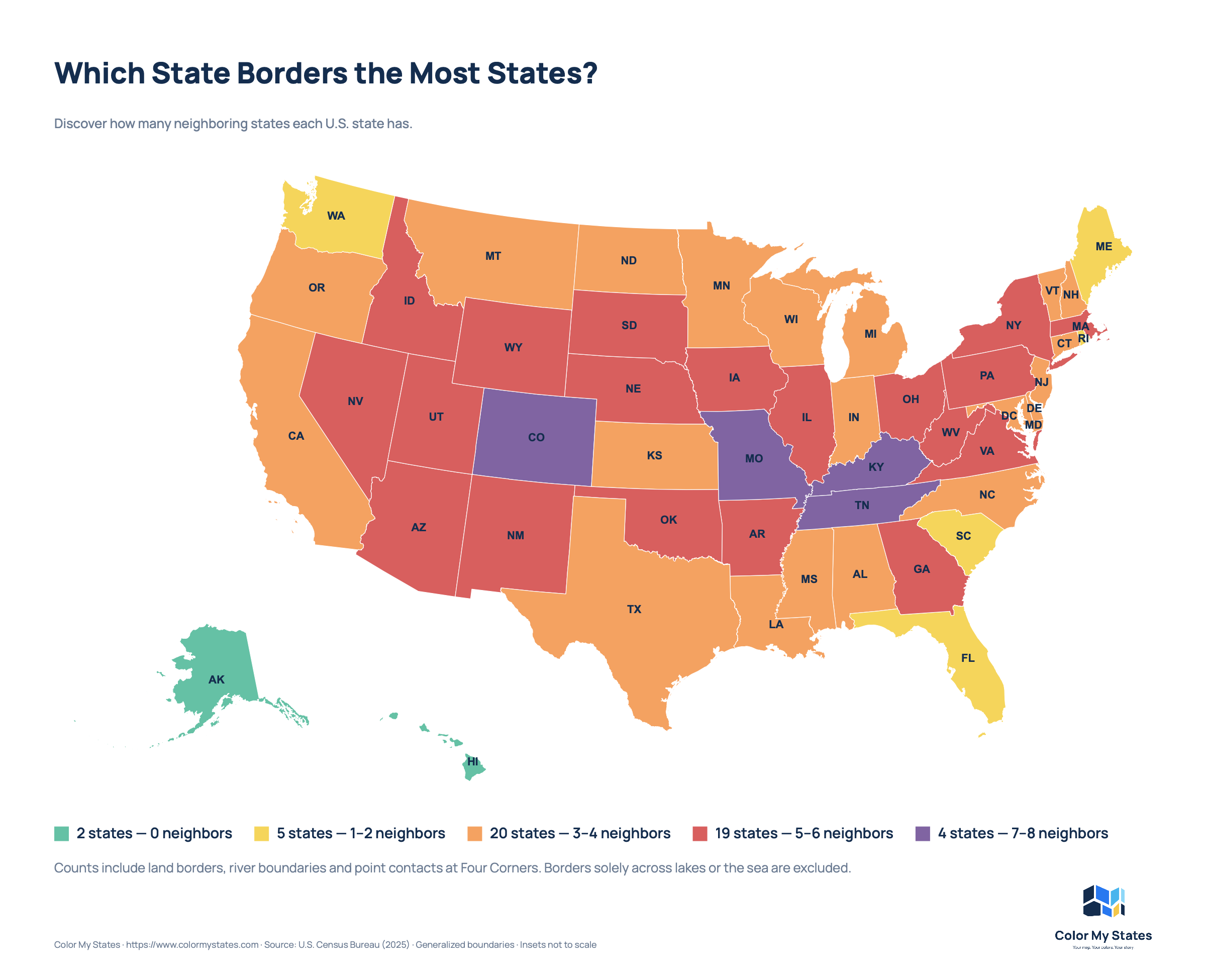
All 50 states and their neighbors
This table follows the same counting rules as the map. State names and their neighbors are listed alphabetically. On smaller screens, scroll the table sideways to see all neighboring states.
| State | Count | Neighboring states |
|---|---|---|
| Alabama | 4 | Florida, Georgia, Mississippi, Tennessee |
| Alaska | 0 | None |
| Arizona | 5 | California, Colorado, Nevada, New Mexico, Utah |
| Arkansas | 6 | Louisiana, Mississippi, Missouri, Oklahoma, Tennessee, Texas |
| California | 3 | Arizona, Nevada, Oregon |
| Colorado | 7 | Arizona, Kansas, Nebraska, New Mexico, Oklahoma, Utah, Wyoming |
| Connecticut | 3 | Massachusetts, New York, Rhode Island |
| Delaware | 3 | Maryland, New Jersey, Pennsylvania |
| Florida | 2 | Alabama, Georgia |
| Georgia | 5 | Alabama, Florida, North Carolina, South Carolina, Tennessee |
| Hawaii | 0 | None |
| Idaho | 6 | Montana, Nevada, Oregon, Utah, Washington, Wyoming |
| Illinois | 5 | Indiana, Iowa, Kentucky, Missouri, Wisconsin |
| Indiana | 4 | Illinois, Kentucky, Michigan, Ohio |
| Iowa | 6 | Illinois, Minnesota, Missouri, Nebraska, South Dakota, Wisconsin |
| Kansas | 4 | Colorado, Missouri, Nebraska, Oklahoma |
| Kentucky | 7 | Illinois, Indiana, Missouri, Ohio, Tennessee, Virginia, West Virginia |
| Louisiana | 3 | Arkansas, Mississippi, Texas |
| Maine | 1 | New Hampshire |
| Maryland | 4 | Delaware, Pennsylvania, Virginia, West Virginia |
| Massachusetts | 5 | Connecticut, New Hampshire, New York, Rhode Island, Vermont |
| Michigan | 3 | Indiana, Ohio, Wisconsin |
| Minnesota | 4 | Iowa, North Dakota, South Dakota, Wisconsin |
| Mississippi | 4 | Alabama, Arkansas, Louisiana, Tennessee |
| Missouri | 8 | Arkansas, Illinois, Iowa, Kansas, Kentucky, Nebraska, Oklahoma, Tennessee |
| Montana | 4 | Idaho, North Dakota, South Dakota, Wyoming |
| Nebraska | 6 | Colorado, Iowa, Kansas, Missouri, South Dakota, Wyoming |
| Nevada | 5 | Arizona, California, Idaho, Oregon, Utah |
| New Hampshire | 3 | Maine, Massachusetts, Vermont |
| New Jersey | 3 | Delaware, New York, Pennsylvania |
| New Mexico | 5 | Arizona, Colorado, Oklahoma, Texas, Utah |
| New York | 5 | Connecticut, Massachusetts, New Jersey, Pennsylvania, Vermont |
| North Carolina | 4 | Georgia, South Carolina, Tennessee, Virginia |
| North Dakota | 3 | Minnesota, Montana, South Dakota |
| Ohio | 5 | Indiana, Kentucky, Michigan, Pennsylvania, West Virginia |
| Oklahoma | 6 | Arkansas, Colorado, Kansas, Missouri, New Mexico, Texas |
| Oregon | 4 | California, Idaho, Nevada, Washington |
| Pennsylvania | 6 | Delaware, Maryland, New Jersey, New York, Ohio, West Virginia |
| Rhode Island | 2 | Connecticut, Massachusetts |
| South Carolina | 2 | Georgia, North Carolina |
| South Dakota | 6 | Iowa, Minnesota, Montana, Nebraska, North Dakota, Wyoming |
| Tennessee | 8 | Alabama, Arkansas, Georgia, Kentucky, Mississippi, Missouri, North Carolina, Virginia |
| Texas | 4 | Arkansas, Louisiana, New Mexico, Oklahoma |
| Utah | 6 | Arizona, Colorado, Idaho, Nevada, New Mexico, Wyoming |
| Vermont | 3 | Massachusetts, New Hampshire, New York |
| Virginia | 5 | Kentucky, Maryland, North Carolina, Tennessee, West Virginia |
| Washington | 2 | Idaho, Oregon |
| West Virginia | 5 | Kentucky, Maryland, Ohio, Pennsylvania, Virginia |
| Wisconsin | 4 | Illinois, Iowa, Michigan, Minnesota |
| Wyoming | 6 | Colorado, Idaho, Montana, Nebraska, South Dakota, Utah |
Make your own state map
You can create a map like this with Color My States. Choose your colors, select the states and add a title and legend.
For an informational map, include a short note explaining what you counted. The note helps readers understand the colors, even when the image is shared separately from the article.
Sources and counting notes
The neighbor lists were checked against these references:
- The Fact File: U.S. States and Their Border States
- Engaging Data: Which State Borders the Most Other States?
These references include water connections that our map excludes. We adjusted the counts for Illinois, Michigan, Minnesota, New York and Rhode Island to match the counting rules described above.