
COLOR MY STATES · BLOG
Which State Has the Most National Parks?
Explore America’s national parks by state and territory—and discover how five colors turn a list of numbers into a map.
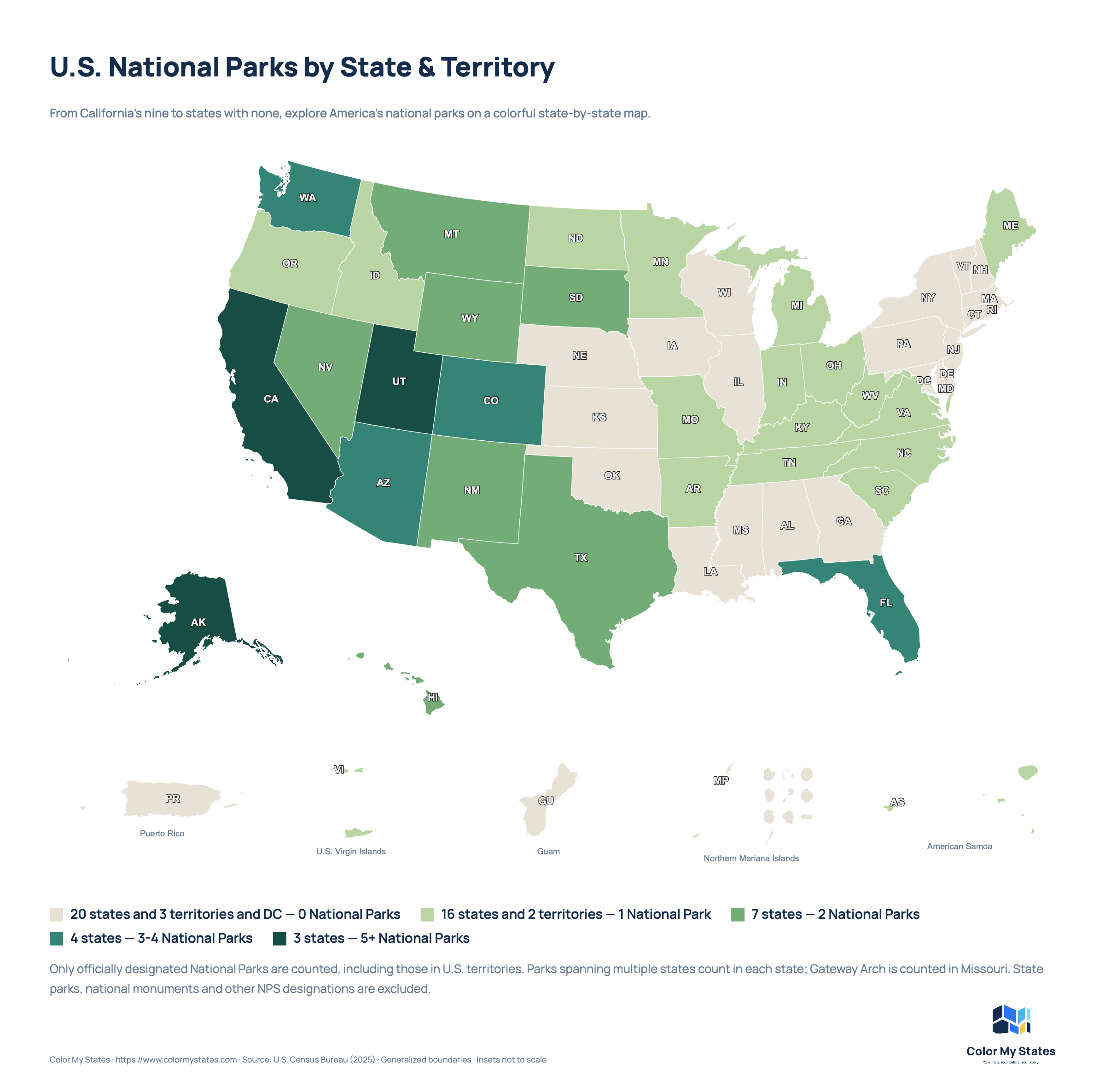
California has the most national parks of any U.S. state, with nine. Alaska follows with eight, Utah has five, and Colorado has four. Arizona, Florida and Washington each have three.
Those numbers are easy to compare in a list. Put them on a map, though, and a different picture emerges. Our Color My States map uses five natural shades to show how national parks are distributed across the country, including Alaska, Hawaii and the U.S. territories.
America’s national parks in five colors
The palette runs from light sand for places without a designated National Park to deep forest green for states with five or more. Follow the colors across neighboring states, spot the darkest areas and see where a single national park puts a state on the map.
| National parks | Map color | Color code |
|---|---|---|
| 0 | Light sand | #E8E2D6 |
| 1 | Soft sage | #B8D5A3 |
| 2 | Leaf green | #73AD77 |
| 3–4 | Deep teal | #338477 |
| 5+ | Forest green | #164E45 |
Five categories keep the legend compact. Each color has a clear place in the sequence: darker means more parks. California, Alaska and Utah share the darkest shade, even though their exact totals differ.
The colors show the number of national parks. They do not represent park size, visitor numbers or popularity.
A large state occupies more space on the map, but that does not automatically mean it contains more national parks. Read the color together with the legend to make a fair comparison.
What do the legend counters mean?
Color My States can display how many states and territories belong to each color category. These counters describe the areas you have colored.
For example, “3 states — 5+ National Parks” means that three states belong to the category for five or more parks. It does not mean those states contain only three parks between them.
This makes the counters useful when checking your map. They help you see how many places fall into each group, while the category label explains what that group represents.
National parks beyond the 50 states
The United States has 63 officially designated National Parks, including two in U.S. territories:
- American Samoa: National Park of American Samoa.
- U.S. Virgin Islands: Virgin Islands National Park.
Both territories receive the color for one national park. Puerto Rico, Guam and the Northern Mariana Islands fall into the zero category. Washington, D.C. is also shown in the zero category and is counted separately from the states and territories.
Including the territories gives the map a broader view of where America’s national parks are located.
What does “0 national parks” actually mean?
A zero on this map has a specific meaning: there is no park with the formal National Park designation under our counting method.
National monuments, national historical parks, national recreation areas and state parks are separate categories. They are not included in these totals.
A light-colored state can still offer protected landscapes, historic places and plenty of outdoor experiences. The map compares one particular category of park; it does not measure everything a state has to offer.
Why the state totals do not add up to 63
Some national parks cross state boundaries. For this map, a shared park counts once in every state in which it is located.
- Yellowstone National Park counts in Wyoming, Montana and Idaho.
- Death Valley National Park counts in California and Nevada.
- Great Smoky Mountains National Park counts in North Carolina and Tennessee.
Adding the state and territory totals therefore counts some parks more than once. The result should not be read as the number of unique national parks nationwide.
Create your own national parks map
You can build a map like this yourself with Color My States. Use the palette above or choose a set of colors that suits your own style.
- Choose your map. Select United States and turn on Include territories.
- Set up your legend. Add five categories: 0, 1, 2, 3–4 and 5+ national parks.
- Add your colors. Enter the color codes from the table or select your own shades.
- Color the regions. Choose a category color, then select the states and territories belonging to it.
- Explain your map. Add a title, description and a short note describing what you counted.
- Download and share. Export your finished map as a PNG or JPG for a presentation, classroom activity, blog or social post.
For small areas such as Washington, D.C., use the region search or zoom in. Temporarily hiding state labels can also make a small area easier to see.
Need help with the editor? Visit our How it works guide.
Make the map personal
You can take the same idea in a personal direction, too. Create a separate map showing states where you have visited a national park, places on your wish list or destinations for your next trip.
Give that map a title and legend that explain your own categories. A map of places you have visited tells a different story from a map showing how many parks each state contains.
The same outline of the United States can help you compare a set of facts or share a story about your own experiences. Choose what your colors will represent.
Sources and counting notes
This map includes only officially designated National Parks. National monuments, state parks and other National Park Service designations are excluded. Parks spanning multiple states count in each state.
Gateway Arch: this map counts Gateway Arch National Park in Missouri, following the park’s own National Park Service website. The general NPS system list also associates the park with Illinois. We state this choice explicitly so the map’s counting method is clear.
The map covers all 50 states, Washington, D.C. and the five permanently inhabited U.S. territories. The U.S. Census Bureau attribution on the map refers to the geographic boundaries; the national park information comes from the National Park Service.
- National Park Service: National Park System
- Yellowstone National Park
- Death Valley National Park
- Gateway Arch National Park
Counts checked October 2026. Park designations and totals may change over time.